Velo Course: Front Range MtB Ramble...

I ride this one frequently, have talked about it, or parts of it, more than enough, and figure it is time to make it part of the Velo course. It, in essence combines two of the My Favorite Routes from the old Claremont Cyclist - the Marshall Canyon-CHWP Loop, originally published in April 2011, and the Palmer-Evey, originally published February 2010 - and more accurately reflects what I tend to ride when I head up into the local hills and canyons. Most of the information here has been culled from those two earlier posts, with a few additions and minor changes.
This little jaunt begins on city streets, transitions to dirt, moves in and out of canyons, skirts across mountain slopes, tops out at one of the more accessible of local peaks, and ends with a fast, let 'er rip, all downhill run for home. Since this is a local ride, my starting point is the front door. It may be for you as well (your own front door) or, if you are more distant, choose the usual starting point at the corner of Baseline and Mills. By starting and ending here, and if you time it right, you have a few choices for a post-ride lunch.


This little jaunt begins on city streets, transitions to dirt, moves in and out of canyons, skirts across mountain slopes, tops out at one of the more accessible of local peaks, and ends with a fast, let 'er rip, all downhill run for home. Since this is a local ride, my starting point is the front door. It may be for you as well (your own front door) or, if you are more distant, choose the usual starting point at the corner of Baseline and Mills. By starting and ending here, and if you time it right, you have a few choices for a post-ride lunch.

an inauspicious beginning to Marshall Canyon

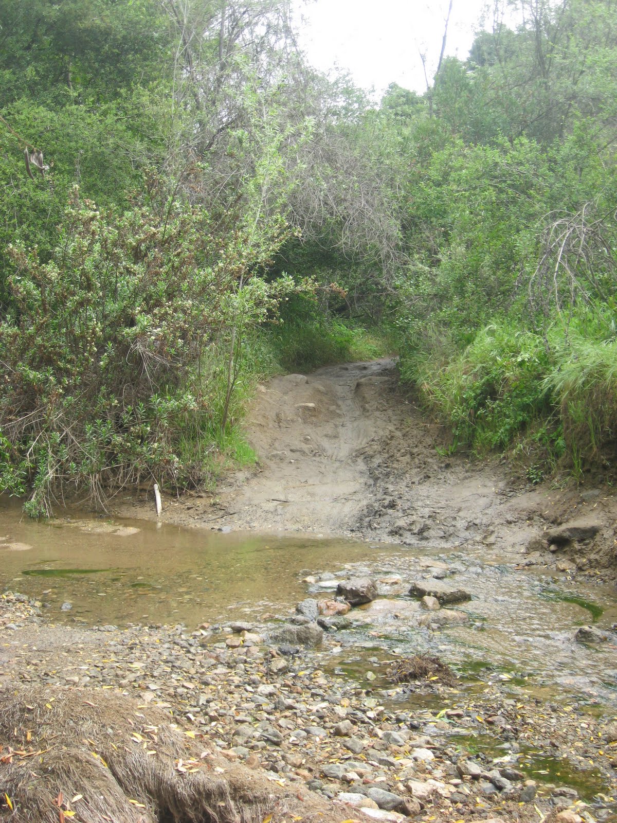
streamside rambling

a rocky crossing
and one smooth as silk

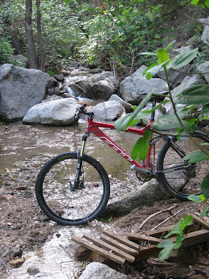
playing in the water
Heading west along Baseline, up and over the Baseline hump at the edge of town, in a little under 5 miles you will come to the Marshall Creek channel. It is nondescript, and if you are not paying attention you can ride right past it. If you notice an elementary school on the left you have gone a little too far and will need to turn around. In either case you are going to follow the dirt and gravel access road along the channel, so ride between the motor vehicle barrier posts and head upstream. You will want to cross the little bridge that shortly shows itself, and navigate a couple street crossings, but before you have gone six miles from the start point you will reach the water detention and debris basin. This is where the Marshall Canyon singletrack, and the fun, begin.

was i riding fast! was i? (there is a 3 Stooges gag in there somewhere)

looking down into Owen's Plunge

canopy and trail

up to the tunnel

revenge of the trees

Spring monkeyflower
From this point the Marshall Canyon section of the route consists of a mostly gently rolling trail inclined gradually upward alongside, and crossing Marshall Creek. The steepest pitches you will find are those where the trail plunges down to the creek bottom and then back up the other side. Usually these are short and you simply give a quick punch to the pedals to climb out. Less experience riders may want to walk some, but there is nothing wrong with that. This lower portion of canyon is deeply forested, majestic old oaks entwining overhead keep it cool and shady on even the hottest summer day. Pockets of wildflowers can quilt the hillsides most times of the year; if you want to get up close though, watch what you touch, as poison oak is especially prevalent. With all the foliage it is easy to see why a small deer herd makes the canyon its home.
After rolling through a few stream crossings, spraying the legs with mud and sand, you will come to a crossing known as Owen's Plunge. There is a concrete basin and some pipes on either side of the crossing. I can't imagine them serving any current purpose, but there they are. How did Owen's Plunge get its name you ask? Well, there was this kid named Owen, who on one of this first mountain bike rides, and based on poor advice from his father, misjudged his speed and the turn before the stream crossing, and plunged head first into the mud and muck beside the water. Live and learn I guess, I know for a fact that the same kid is a singletrack daemon these days. Anyway, after the Plunge, you will come to, and ride onto, the Marshall Canyon golf course. Follow the concrete path, or the muddy track alongside it until it reenters the woods at yet another stream crossing. For some reason I especially like taking this one at speed. In a short distance you will come upon some old wooden structure in the midst of the oaks, which I always assumed was some sort of clandestine equestrian meeting place, but is now being reclaimed by the woods. Because there is a relatively large open area here, group rides will often regroup at this spot. And since I bring up the point of equestrians, keep in mind that Marshall Canyon is in the middle of horse country, there are also a lot of trail runners from local schools, and day hikers. Keep your eyes and ears open as you ride along.

choose right or left, it's up to you

top o' the right route looking back down

the plateau, where the trails come together

deer herd feeding on the plateau
You have come upon a few trail junctions by now, but have bypassed them all in favor of staying on the main, creekside trail. When you ride away from the old wooden structure, you have two options: First, you can veer right, cross the stream and head up hill out of the canyon, or second, you can continue following the stream to the left. The two paths will meet up further along. The left route packs in many stream crossings in a short distance, before a minor technical climb out of the canyon. The route right, takes you on a more evenly gradual climb out. I usually go right, but only because I like to make a mini-loop by riding back down the other way (quite fun splashing through all those stream crossings at speed you know), and then back up to continue on. The two trails come back together at an open plateau area, and outside the gates of a large equestrian event area. You will continue rolling along the undulating trail up above the canyon, briefly plunge back down into its wooded depths, before the trail t-bones a dirt fire road. You could actually go either way here, and if you like exploring try both, they go different places, but ultimately both enter the CHWP. For simplicities sake, we are going left today. Climb out of the sandy canyon bottom by either the fire road, or the sometimes faint trail which starts out by following the normally dry, sandy creek bed; again, they shortly merge just ahead anyway.

not the only one on the trail today, but nearly so

blue dicks, go ahead and laugh, but that is the common name

with apologies to Scotland, those things suck when they dry out,
thorns in your hands and legs if you stray too close

all the moss would suggest that it is a bit shady down here

trail junction / rest area

go right, definitely go right
If you have followed my directions and gone left where mentioned above, you will, sooner or later, merge onto another dirt road. This is the Palmer-Evey, another portion of which I highlighted in an earlier My Favorites posting. Keep pressing ever upward, moving in and out of shady woodland and sunny, exposed mountainside. Eventually you will come to another major trail junction, with a picnic table in the shade of the oaks, and beside the stream. This is the perfect spot for a moment of rest. Whether you follow the single track to the right and across the steam, or stay with the dirt road, your route is now going to become steep and, in the summer, hot. Now, I know you are tempted by that word single track, and want to go right but, as much as I favor climbing to descending, that way is much preferable coming down than going up. Therefore, I am sticking to the road. That said, in another 50 yards, definitely do take a second single track branching off to the right - both routes will meet further along. I don't know if the trail is slightly longer and thus somewhat more gradual, or if being single track just makes it more fun to ride, but I loath that short section of road, and... I took it today anyway. As things tend to do here, both ways shortly merge again and, even if you took the trail, you will find yourself on the Palmer-Evey once again. Continue following the road upward, above the canyon, in the sun, dripping sweat the entire time. Hey, it may have been cooler today, but it was also humid as heck, the mountains wreathed in mist. The remainder of the route up to the CHWP is mostly unremarkable. I think the local apiarist has his bee hives out on the plateau (if you know what and where I mean) since the little buggers were streaming back and forth across the road, and all around me, or so it seemed. We mostly were able to avoid colliding with one another. At the gate you will crest, then enter the CHWP, where a map will greet you if you are not familiar. Go left, tackle a short uphill stretch, and then start a nice and welcome downhill stretch of road.

we were at that reservoir a few minutes ago

the little Palmer Evey Fire Reservoir and the road to Potato Mountain

the final steep push up Potato is the more distinct road;
downhillers like to descend on the less distinct parallel trail

always a sense of accomplishment when you can look back down on the road

view to the southeast

looking out over Claremont from Coyote Howl Plateau
That downhill ends all too quickly at the next, signed, road junction, also marked by a water tank. At this junction take the left, uphill road, quickly shifting into an easier gear because it may be short, but it is also steep. Since this is a dirt fire road, it is not the type of ride that mountain bikers go out of their way to do. Never-the-less, it does have it's attractions, some obvious, some hard to find. From the last junction, the Palmer-Evey climbs and dips in and out of the canyons of the San Gabriel Mountains' front range. On clear days, like today, the views out across the valley below and to the distant snow-covered peaks, Mt. San Gorgonio and Mt. San Jacinto, are spectacular. Up close, wildflowers often cover the hillsides in a petaled mosaic of purples, reds, golds, yellow and white. There are some steep sections of road that will have you huffing and puffing, but about 3/4 to 1 mile further along, the road delves into one of the larger canyons, the West Fork of Palmer Canyon, and you can cruise along at a more relaxed pace and level grade. The slopes of this canyon are deeply shaded by a large extended family of oaks. Other than Marshall, this is the only canyon along the Palmer-Evey through which a stream flows year-round. That means that a small cluster of Alder grows here, and the local deer herd can often be seen grazing during the hot summer months. While the CHWP is daily invaded by crowds from the urban area, this part of the Palmer-Evey is rarely visited.
 soak in the view


Springtime Lupine
After leaving the shade and sound of gurgling water of the canyon behind you, the road wends ever upward, at a mostly pretty consistent grade. Every so often you round a ridge and head into another canyon were you can see the road way high up the other side of the canyon. If you have never done the route before this might be one of those "I have to go up there" moments, but disregard the urge to stop and turn around. A few bends of the road past the West Palmer Canyon you round into the main branch of Palmer Canyon. Way down below are some ruins of houses destroyed a number of years ago by fire, and way up above one of those road views I just mentioned. At the head of the canyon used to be an Angeles National Forest boundary sign which, interestingly, seemed to disappear at the time the city expanded the CHWP. Hmm? The road also briefly ticks up in steepness, so punch it good and then settle back into a nice rhythm. Sooner than expected you reach another little shaded hilltop road junction with a small stream hidden off to the left. There is a steel firebox here and a small concrete reservoir up the hillside. At this junction you could go left and down Evey Canyon to Mt. Baldy Road, but today we are going to Potato Mountain, so go right up the quite rutted dirt road. If you go into the barbed wire enclosure at the top of this rise there are some nice views way back along the road you were just on. Carrying on, there is a short fast descent before you come face to face with the final painful push to the top of Potato. Quite frankly I put this climb in the brutal category, and it was not until this latest ride that I actually rode the whole way up, stopping occasionally to let my breath catch up, but no being forced to hoof it, as I have always previously done.
Spend as much time as you need recovering at the top, there are wide views all around. Look for the pile of potatoes on the circular concrete platform, drink some water, eat something, have someone take your picture on top of the world, and then head back the way you came. When you once again reach the water tank on the main loop trail of the CHWP continue downhill through the red dirt of Little Sedona, and into the shady depths of Cobal Canyon. Used to be, before the park became so popular, that you could really run fast down here, but not so much any more. Never-the-less, after the first (usually dry) stream crossing there will be a short section of road that is perpetually wet and muddy. If there is no threat of spraying passing walkers, take the wettest, muddiest line you can find, it will be your last chance to make it look like you have been on an adventure. Spot the rocks in the middle of the roadway that will allow you to get a little air, take one final usually dry stream crossing at speed before you reach the Park's parking lot.

We are not quite done with the dirt yet though, so head down paved Mills Avenue until you reach the gated Thompson Creek Trail (TCT) on the right (and opposite the lower parking lot). Go around the motor vehicle barrier and head down the paved path. Very soon you will see a slight rocky dirt trail on the left. Merge that way. This is a little trail I call 'Powerline' for reasons that will be obvious. I love to tack on this short section to end the ride. In this direction it tends downward and since there is rarely anyone else on it, you can truly fly down this double-track utility access route. It ends at the TCT - continue down to the next gate, go left on the residential street, take it all the way to Mills, go right and it is downhill all the way back to the start point. Believe it or not, for all the pedaling it seems like you have just done, the distance comes in at under twenty miles, with about 4300 feet of elevation gain.

Spend as much time as you need recovering at the top, there are wide views all around. Look for the pile of potatoes on the circular concrete platform, drink some water, eat something, have someone take your picture on top of the world, and then head back the way you came. When you once again reach the water tank on the main loop trail of the CHWP continue downhill through the red dirt of Little Sedona, and into the shady depths of Cobal Canyon. Used to be, before the park became so popular, that you could really run fast down here, but not so much any more. Never-the-less, after the first (usually dry) stream crossing there will be a short section of road that is perpetually wet and muddy. If there is no threat of spraying passing walkers, take the wettest, muddiest line you can find, it will be your last chance to make it look like you have been on an adventure. Spot the rocks in the middle of the roadway that will allow you to get a little air, take one final usually dry stream crossing at speed before you reach the Park's parking lot.

Powerline, ride it fast
We are not quite done with the dirt yet though, so head down paved Mills Avenue until you reach the gated Thompson Creek Trail (TCT) on the right (and opposite the lower parking lot). Go around the motor vehicle barrier and head down the paved path. Very soon you will see a slight rocky dirt trail on the left. Merge that way. This is a little trail I call 'Powerline' for reasons that will be obvious. I love to tack on this short section to end the ride. In this direction it tends downward and since there is rarely anyone else on it, you can truly fly down this double-track utility access route. It ends at the TCT - continue down to the next gate, go left on the residential street, take it all the way to Mills, go right and it is downhill all the way back to the start point. Believe it or not, for all the pedaling it seems like you have just done, the distance comes in at under twenty miles, with about 4300 feet of elevation gain.

Comments
Post a Comment