Velo Course: High Rolling The G's...
That's 'Gs' as in Glendora Mountain Road and Glendora Ridge Road.
This is the most accessible of road loops into the local mountains starting from Claremont, and I have written about it previously here (March 2012), here (May 2012) and, most recently, here (June 2013). Because of that there are not as many photos here, nor as much text, yet the ride is surely Velo course worthy, and is therefore being presented once again. If you have followed this blog for any length of time, and perhaps even if you have not, you may know that Glendora Mountain Road and Glendora Ridge Road count themselves among the creme of the regions iconic mountain road climbs. By the time you have run the circle of the mountain you will end up with almost 43 miles and 4500 feet of elevation gain.
Due to the north facing slope along which much of the route progresses, as well as its elevation, I would technically call this a three season ride, though since winter snows can be questionable and, many years fashionably late, the loop can often be done well into December. For my dollar though, Spring is the best time to do this one - the mountainsides are green, the skies are at their clearest, wildflowers splash the canyons with color, butterflies and wildlife are special treats. Be that as it may, the heat of summer provides a little extra challenge to the loop, while the quiet of autumn is a welcome all its own.
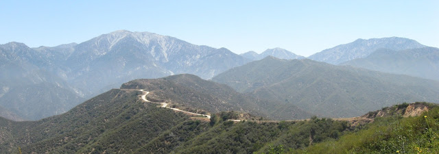
Given the proximity to the urban area below it can be somewhat surprising just how little traffic passes by on these roads; Mt. Baldy Road excepted. Given the proximity to the urban area below it is surprising just how isolated this area can feel at times. Even so, and by my estimation, the route just barely touches upon the high country - Mt. Baldy steals up close to you, yet a deep canyon separates. Pines form up into ranks here and there, yet they seem like lonely sentinels in a sea of chaparral. While clouds may shroud Baldy and its attendant peaks, you can ride for mile after mile in warm sun. I suppose the term high country means different things to different people, for me most of this ride involves a progression to reach that sliver of attainable height. Perhaps that is why it is completed with a sense of accomplishment as reward - to toil upward from civilization, into the mountains; a gradual if steady transition, long miles wearying the legs, before plunging back down, like the shock of a dive into a cold mountain lake. There are fantastic, wide ranging views along the entirety of the route - into deep, dark canyons, across to distant peaks, along the great scar of Cattle Canyon disfiguring Baldy's flank. Stop and look behind you from time to time, to see the East Fork of the San Gabriel River receding away, as well as lower front range peaks stacked upon one another. Ponder the scale of what is around you, the views that unfold with each bend in the road, and compare them to your own small self on that narrow ribbon of roadway. Perspective.
The route: Start from the usual spot at the Vons parking lot, corner of Mills and Baseline and head west along that latter road. Make the merge onto Foothill and continue west into Glendora where the street name changes to Route 66. At Lone Hill Avenue make a right then, followed a half mile later, by a left onto Foothill. Make another right onto Valley Center; follow it north toward the mountains for a mile or so, then make a left onto Sierra Madre Avenue and, almost immediately, another right onto Glendora Mountain Road. Stick to GMR until it peaks out at the top of the Monroe Truck Trail (unmarked - ToM on map) and then drops to an intersection. GMR at this point plunges down to the East Fork; you, on the other hand, will continue upward along Glendora Ridge Road. There are no legal, paved turnoffs along GRR, so no worries of a wrong turn. Follow along to Cow Saddle, then drop into Baldy Village. At the intersection with Mt. Baldy Road, turn left to reach food and beverage, or right for the steep and fast descent back to Claremont. Stay on Baldy Road until you reach Mills, make a left, and return to the start point. Simple as that.
Consider your water needs - there is none available until you reach Baldy Village. Consider the elevation, the sun can beat down ferociously on summer days and there is little cover. Remember that the weather can change quickly during certain times of the year, and that wind can play havoc the closer you get to Baldy and San Antonio Canyon. Remember to look around, there is a lot to see.


Certainly is nice to have something like it so close.
ReplyDelete